- Home |
- Why With Us |
- About Us |
- Booking |
- Contact Us |
- Site Map


The Annapurna Circuit Trek
Days from
The Annapurna circuit is a classic trek in central Nepal that stretches for 300km (186 miles) around the Annapurna Mountains in the Himalaya. The trek begins at low elevation and climbs up to 5,416 meter (17,769ft) at Thorung La pass.
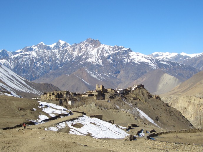
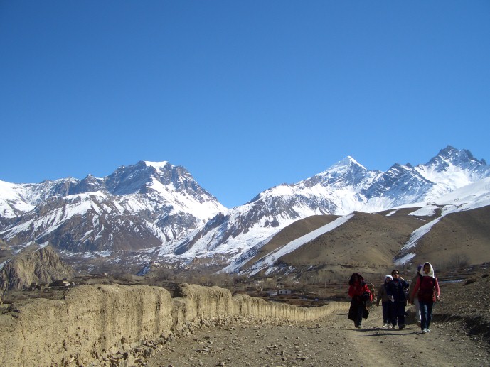
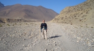
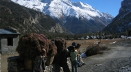
The journey passes through dozens of lowland and high mountain villages and some of the most spectacular natural scenery in the world.
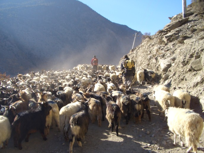
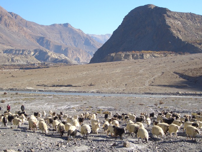
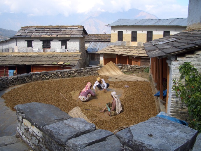
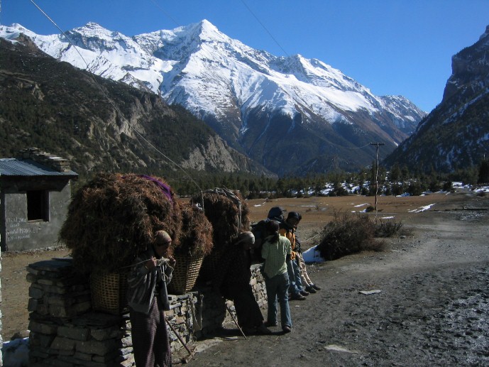
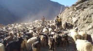
Setting foot on the Annapurna trail is like stepping back in time. The trappings and distractions of modern society vanish. Life goes on in the mountain villages much as it must have a century ago. Gone are the sounds of cars, motorcycles, or machines of any sort. In their stead are the sounds of rivers and waterfalls, of women tending gardens, children walking to and from school, men porting goods or playing cards.
| Max. Elevation : 5,416m | Grade : |
| Best season : Sep-Dec&Feb-June | Type of trek : Tea house/Lodging |
| Duration : 24/22 Days | Starting point : Besisahar |
| Ending point : Kathmandu | Highlights : Nature |
The Annapurna Circuit is perhaps the most popular name for a 300 kilometer trek in Nepal around the Annapurna mountain range in the Himalayas. As the name suggests, this trail goes on a circuitous route around the entire Annapurna massif, visiting the Tibet-like country on the northern slopes of the Himalayas and the dramatic Kali Gandaki gorge. It is the classic long-distance route in Annapurna.
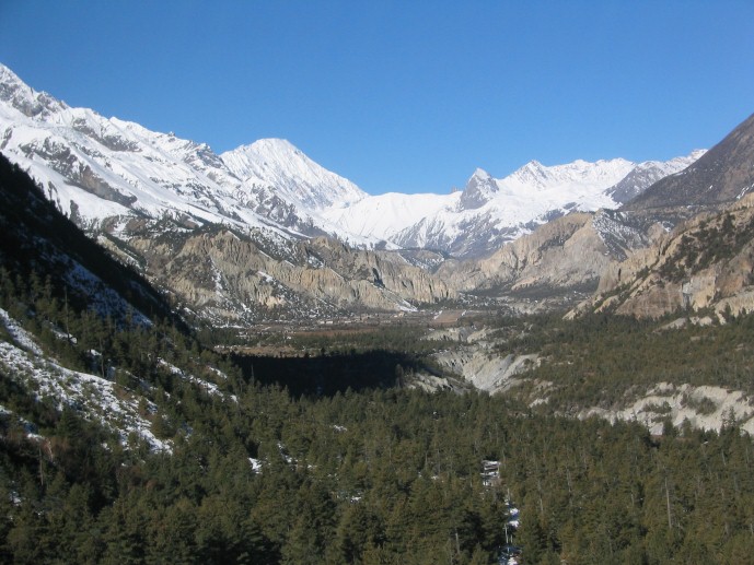
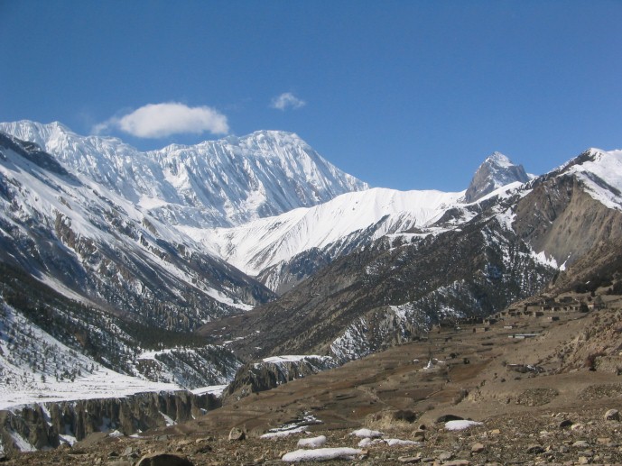
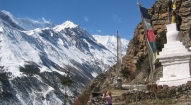
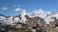
The trek reaches an altitude of 5,416 metres on the Thorung La pass, touching the edge of the fabled Tibetan plateau. The magnificent mountain scenery, seen at close quarters includes Annapurna 8,091 meters which was the first 8,000 meter peak to be climbed, the magnificent ice pyramid Dhauligiri 8,167 metres, once the home of the legendary Buddhist guru Padmasamba, and Machhupuchhare 6,993 meters, considered by many to be the most beautiful mountain in the world.
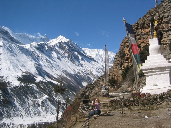
The trek follows ancient paths used as trade routes between Nepal and Tibet. These paths have long facilitated the flow of cultures and religions in this remote and formerly inaccessible region. Today Tibetan Mahayana Buddhism, Hinduism and the mysterious Bon-Po religion still coexist and interpenetrate one another in this region which contains many pilgrimage sites. The unusually wide range of climatic zones in such a small area as the path ascends from 900 meters to 5,300 meters provides a chance to see many different plants and animals, and the different ways of life of the many peoples who live there. The trail winds through dozens of villages that offer glimpses into traditional Nepali village life. Largely Hindu in the lowlands, the villages gradually reflects Tibetan influences as we climbed higher into the mountains, Hindu icons giving way to Buddhist prayer wheels and gompas (temples).
Outline Itinerary
Day 01: Arrive Kathmandu International Airport (1300m/4264ft), transfer to hotel
Day 02: Guided sightseeing of Kathmandu valley’s cultural, historical and religious sites followed by welcome dinner in the evening with live Nepalese culture shows.
Day 03: Drive Kathmandu- Besisahar (760 m). (approx. 6 hrs drive)
Day 04: Besisahar - Bahun Danda (1310 m) – 5 hrs walk
Day 05: Bahun Danda - Chamje (1430 m.) – 6 hrs walk
Day 06: Chamje - Dharapani (1860 m.) – 6 hrs walk
Day 07: Dharapani - Chame (2670 m.) – 5 hrs walk
Day 08: Chame - Pisang (3200 m.) – 6 hrs walk
Day 09: Pisang - Manang (3540 m.) – 4 hrs walk
Day 10: Rest at Manang. Stroll around at Manang.
Day 11: Manang - Yak Kharka (4018 m.) – 5 hrs walk
Day 12: Yak Kharka - Throng Phedi (4450 m.) – 4 hrs walk
Day 13: Thorang phedi - Thorang pass (5416 m.) descend to Muktinath (3800 m.) – 8 hrs walk
Day 14: Muktinath - Kagbeni (2800 m.) – 3 hrs walk
Day 15: Kagbeni - Jomsom (2710 m) / Marpha (2670 m.) – 5 hrs walk
Day 16: Marpha - Kalopani (2530 m.) – 6 hrs walk
Day 17: Kalopani - Tatopani (1190 m.) – 6 hrs walk
Day 18: Tatopani - Shikha (2830 m.) – 5 hrs walk
Day 19: Shikha - Ghorepani (2750 m.) – 3 hrs walk
Day 20: Ghorepani - Ghandruk (1940 m.) – 7 hrs walk
Day 21: Ghandrunk - Pothana (1900 m). – 5 hrs walk
Day 22: End trek at Phedi (3 hrs walk) and drive to Pokhara (30 min drive).
Day 23: Drive or fly back to Kathmandu
Day 24: Final departure
If you would like the freedom to design your own itinerary and include activities you like doing most, during your Annapurna Circuit Trek, we would be happy to tailor this trip to your interest and needs.
Day by day itinerary
Day 1: Arrive Kathmandu, transfer from airport to hotel.
Day 02: After breakfast we set out for an extensive guided sightseeing tour of Kathmandu valley’s cultural, historical, religious and world heritage sites. During the course, we visit the famous Pashupatinath temple of Lord Shiva situated at the holy bank of River Bagmati where we will also witness the Hindu cremation ritual. We then proceed to the Boudhanath Stupa, a major pilgrimage centre for the Buddhist faith and the Stupa is the largest of its kind in the whole world. We then have a short break for lunch followed by a visit to Swoyambhunath Stupa also known as the Monkey Temple from where we can have a bird’s eye view of whole of Kathmandu valley. Following this we then proceed for a visit to Kathmandu Durbar Square, the oldest royal palace of Kathmandu and a UNESCO world heritage site. The whole are of Kathmandu Durbar Square is dotted with numerous fascinating Nepalese architect dating back many centuries. The site is also the home of Nepal’s living Goddess known as Kumari where we will also have the opportunity to experience firsthand this unique Nepalese custom. In the evening we will attend the welcome dinner hosted by Makalu Adventure with live Nepalese cultural show.
Day 3: Drive from Kathmandu to Besi Sahar.
Day 4: Besi Sahar - Bahundanda
We start our trek at Besi Sahar (820m) and continue on to the Gurung village of Khudi at 790m where we cross the Khudi Khola. From here we follow the trail northwards up the Marsyangdi valley to Bhulbule where we stop for lunch. The trail then crosses the Marsyangdi on a long suspension bridge and continues up the east bank of the river. From here there are good views of Manaslu (8156m) to the north-east. The trail then leads up through the villages of Ngadi and Lampata before reaching Bahundanda (1310m) where we spend the night.
Day 5: Bahundanda - Chamje
From Bahundanda the trail drops to eventually cross a stream and then climbs to the settlement of Lili Bir. The trail continues high above the river eventually dropping to cross to the western side of the Marsyangdi at Syange (1190m). Beyond Syange the trail becomes steep in parts, reaching the ancient village of Jagat at 1250m. From Jagat the trail descends to the Marsyangdi, and follows the riverbank before climbing up through forests to Chamje at 1430m.
Day 6: Chamje - Bagarchhap
Today the trail continues northwards before eventually turning to the north west as it follows the Marsyangdi to Bagarchhap. The trail initially crosses the river to the east bank and climbs up to the large settlement of Tal at 1675m, where there are many shops and lodges. From Tal the trail crosses and then re-crosses the river as it makes its way to Karte, and finally crosses again to the west bank before continuing through the village of Dharapani at 1920m, and on to Bagarchhap at 2160m.
Day 7:Bagarchhap - Chame
From Bagarchhap the trail continues in a general westwards direction up the Manang valley, following the Marsyangdi river. Throughout today we obtain views of Annapurna II (7937m) and Annapurna IV to the west. Initially the trail climbs through forests to Dhanakyu at 2290m, and continues steadily to the settlement of Lattemarang at 2360m. The track then climbs over several forested ridges to reach the village of Kotho at 2590m, and from here it is an easy half-hour walk to Chame at 2630m, the administrative headquarters for the Manang district.
Day 8: Chame - Pisang
From Chame we cross to the northern side of the river and trek west on an easy trail to the village of Bhratang at 2840m. From here the valley is steep and narrow and leads through dense forests. The trail eventually crosses back to the south side of the river on a suspension bridge at 3040m and then continues on to our destination for the evening, the large village of Pisang at 3190m, where there are many lodges.
Day 9: Pisang – Manang
The trail continues on the south side of the river and makes a long climb over a ridge to reach approx 3400m. It then descends to the valley floor and continues on to Hongde at 3325m where there is an airstrip, several lodges and a police checkpost. The feature of the village is a long mani wall. The trail crosses to the north bank of the river near Mungli and continues on to the stunning Tibetan-style village of Bryaga at 3475m, where there is an ancient gompa. From here it is only a short walk to Manang at 3500m. Manang is a very large and important village with numerous shops and lodges.
Day 10: Acclimatisation day at Manang
This is an acclimatisation day which will allow us to become adjusted to the thinning air and lessening pressure as we continue upwards towards the Thorung La. It is often useful to make use of this day by taking a gentle excursion to a number of the interesting areas near to Manang. However it is also useful to rest up and relax before we trek higher.
Day 11: Manang - Yak Kharka
Whilst it is possible to reach Thorung Phedi in one day from Manang we split the journey in two in order to aid acclimatisation. From Manang we trek slowly up to Tengi at 3620m and continue steadily upwards to Gunsang at 3930m. The trail is now distinctly alpine in appearance, the vegetation consisting of scrub juniper and alpine grasses. The views en route across to the immense peaks of Gangapurna (7454m) and Annapurna III (7555m) are fantastic, as we continue up to Yak Kharka at 4090m. There are several lodges here and although it makes for a short day, it is a convenient place to stop before trekking higher.
Day 12: Yak Kharka - Thorung Phedi
From here we continue very slowly upwards reaching the small settlement of Letdar, at 4250m, after about one hour. The trail then continues to climb along the east bank of the Jarsang Khola, making its way steadily up to Thorung Phedi, a small collection of lodges, at 4420m. This is our last stop before crossing the Thorung La – “phedi” means “foot of the hill”, and indeed this is the starting point for the long trek up to the pass at 5416m. This is another short day, and allows us to rest and relax before ascending to the pass tomorrow. Lodges here are usually very crowded and there is an air of excitement and a lot of activity as most trekkers arrive here by lunchtime.
Day 13: Trek - Muktinath, crossing Thorung La
We set off early, at about 6am, and begin the long climb up to the Thorung La (“la” means “pass”) 1000m above us. We trek slowly and steadily and aim to reach the pass in 4 hours from Phedi, although it can take less or more depending upon fitness and acclimatisation. The trail has been used for centuries by local people and is well defined in the trekking seasons. Upon reaching the pass we see the traditional chorten, prayer flags, and cairn, and other trekkers resting before the descent to Muktinath 1600m below. The views from the pass can only be described as breathtaking, and take in a panorama of Himalayan giants, as well as providing our first view of the immense Kali Gandaki valley to the west. The reduction in altitude becomes obvious as soon as we leave the Thorung La and it is amazing how much difference this makes in only a few hundred metres. As we descend, we obtain great views of Dhaulagiri to the south-west, and Tukuche Peak at 6920m. The descent is long and tiring but not difficult and we soon find ourselves down in Muktinath and Ranipauwa, although this does take about 3 hours. There are many lodges here and we spend the rest of the day relaxing and looking back with satisfaction on a great achievement - crossing the Thorung La.
Day 14: Muktinath – Jomsom
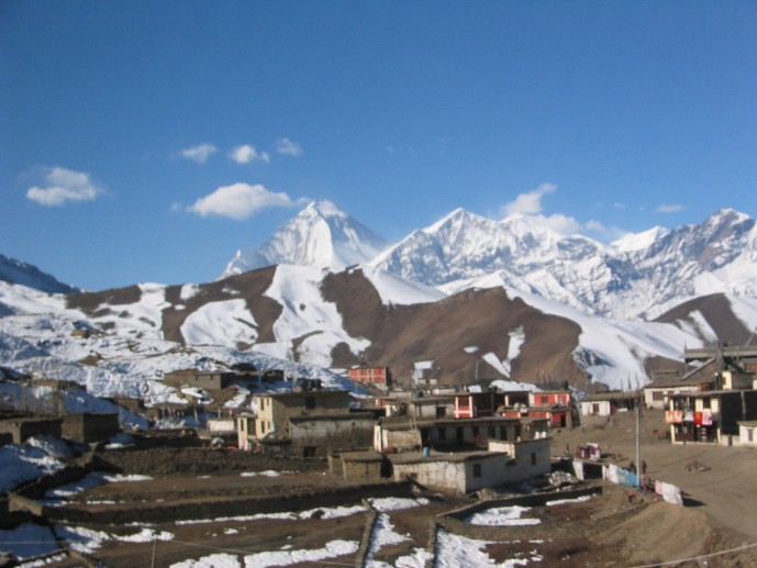
We can now look forward to a reduction in altitude and easier going, as we descend down the trail to Jomsom. From Muktinath we descend to Jharkot (3500m), a picturesque village with many interesting features and from here continue down to Khingar at 3200m, and eventually Kagbeni at 2801m. Kagbeni is at the junction of the Jhong Khola and the Kali Gandaki, and is the northernmost village that can be visited in this region with a normal trekking permit. North from here, the trail to Mustang begins and trekkers must have the correct documentation if they wish to trek there. It is worth spending some time to look around Kagbeni; at the narrow alley ways and the large gompa. From here we follow the river down to Eklai Bhatti (2730m), where we join the alternative and more direct route from Muktinath. From here it is an easy walk to Jomsom, the administrative headquarters of the region, at 2713m.
Day 15: Jomsom - Kalopani
From Jomsom we continue to descend the Kali Gandaki valley, passing through the substantial settlement of Marpha at 2665m with many hotels and a large Gompa, and then down to Tukuche at 2590m. On the route we notice a distinct change in the surroundings from barren, dry country to greener, more welcoming pine and conifer forests. Tukuche is a beautiful Thakali village and it is worth resting here to take in the atmosphere of this famous trading town where Tibetan traders from the north met with those coming up from the south. From Tukuche we continue along the trail through the villages of Khobang (2560m) and Larjung (2560m) and eventually reach Kalopani at 2560m. We have fantastic views of the big mountains in this area all through the afternoon, especially Dhaulagiri at 8167m and Nilgiri at 7061m.
Day 16: Kalopani - Tatopani
Today we trek back into the more subtropical part of Nepal and the trip takes on a different feel. We continue along the river passing through Lete at 2470m and Ghasa at 2080m. A highlight of the day is the small village of Rupse Chhahara at 1550m. Here there is a beautiful waterfall, after which the village is named. The trail crosses the river numerous times during the day and we lose a lot of height, as the altitude of Tatopani is only 1180m. Tatopani, means “Hot water” in Nepali and it is named after the hot springs near the village. Tatopani is a large village with an amazing selection of high quality hotels, many with garden restaurants and access to the riverside springs.
Day 17: Tatopani – Ghorapani
Today is another hard day, but by now we should be fit and acclimatised. After losing height during the last few days we now climb back up to the pass at Deorali at 2834m where there are many hotels. Ghorapani is a few minutes past here at 2775m. The trail is upwards for all of the day passing through many settlements on the way, such as Ghara at 1705m, Sikha at 1980m and Chitre at 2390m where we trek through rhododendron and magnolia forests. The hard work is worth it as the view from Deorali, of a panorama of peaks, is absolutely stunning.
Day 18: Ghorapani - Tikhedhunga
Many trekkers will take the opportunity of an early morning trip up Poon Hill (3210m) for the best view of the peaks in the region. The walk up takes about one hour and is certainly worth it, with many making a special effort to get there for the sunrise over the 8000m peaks. After the side trip to Poon Hill and a well-earned breakfast we lose height again as we trek downwards to Tikhedhunga at 1525m. The trail today is a reverse of yesterday, easy on the lungs but hard on the knees. We pass through Nangathanti (2460m) and Banthanti (2250m) and eventually reach Ulleri at 2070m. From here it is a long desecent on a stone staircase before we reach the Bhurungdi Khola at 1410m - from here it is a short walk to Tikhedhunga.
Day 19: Tikhedhunga - Naya Pul, drive back to Pokhara. Overnight in Pokhara.
Today is the last day on the trail. We continue down the trail to Birethanti, and from here walk the short distance to the roadhead at Naya Pul, where we are picked up by our transport and driven back to Pokhara. The journey by road takes approx. 2 hours and we arrive back in Pokhara by early afternoon, in time to refresh ourselves in the hotel before spending a night in Pokhara.
Day 20: Pokhara - Kathmandu by flight, rest of the day is at leisure.
Day 21: After breakfast we will set out for a sightseeing tour of Bhaktapur and Patan and return to our hotel at late afternoon
Day 22: Transfer from hotel to airport for final departure
- All airport/hotel transfers
- All accommodation in Kathmandu and Pokhara and wherever stated
- Welcome and farewell dinner
- All accommodation and meals during the trek
- Domestic flights (wherever stated on the itinerary)
- Trek leader, assistant trek leader) Sherpa porters including their salary, insurance, equipment, flight, food and lodging
- Down jacket, sleeping bags, Trekking kit bag/duffel bag, trekking map and trekking Poles
- All necessary paper work and permits (National park permit or entrance fees etc)
- A comprehensive medical kit
- All government and local taxes
- Nepal visa fee
- Airport departure tax
- International airfare to and from Kathmandu
- Excess baggage charges
- Lunch and evening meals in Kathmandu and in Pokhara
- Extra night accommodation
- Travel and rescue insurance
- Personal expenses (phone calls, laundry, bar bills, battery recharge, extra porters, bottle or boiled water, showers etc)
- Tips for guides and porters