- Home |
- Why With Us |
- About Us |
- Booking |
- Contact Us |
- Site Map


Nar and Phu Valley Trekking
Days from
In the early 1980, sociologist Christph von Furer Haimendorf and a team of researchers who visited the region later wrote that “ the decision of the Government of Nepal to not expose such regions to the increasingly flood of tourist had had the great advantage of shielding at lease a small percentage of mountain dwellers from the commercialism of tourist trade which has already transformed the social and cultural patterns of such communities as the Sherpas of Khumbu.
| Max. Elevation : 5416m | Grade : |
| Best season : Mar-June&Sep-Dec | Type of trek : Tea house/Lodging |
| Duration : 17 Days | Starting point : Beshisahar |
| Ending point : Kathmandu | Highlights : Culture/Nature |
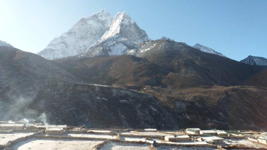
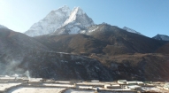
Hidden beneath the swirls of mountain mist, the Nar and Phu valleys are the newly opened spectacular region of ethnically Tibetan inhabitants, above the tree line on the upper limits of cultivation, in the very north of Manang district. Opened to the visitors only in 2003 by the Nepal Government, the region is a dazzling canvas of unearthly landscape, medieval Tibetan culture and dramatic mountain scenery.
The region of Nar and Phu was first explored by Bill Tilman in the 1950s and since its opening in the year 2003, only a few westerners have visited this virtually untouched region or climbed the many 7000m peaks surrounding the it. Climbing expedition have been visiting the region since the 1950s to attempt the nearly 7000m Mt. Kanguru whose imposing western flanks dominates the approach to these valleys.
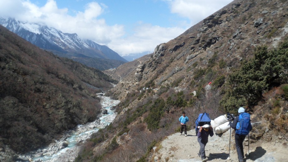
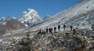
Located north of the Annapurnas, the Nar and Phu valley trek takes the visitors into less trodden and remote region of Nepal beyond the regular trekking routes and offers an affordable alternative to the expansive Mustang region and the increasingly congested Annapurna circuit trekking adventure. The trek is a classic combination of high peaks and passes, glacier, remote villages, narrow canyons, lovely forests, amazing rock formation, yaks, gompas and unique Himalayan cultures. Trekking the standard Annapurna circuit, the bridge leading over the Marshyangdi River to the steep portals of the Nar Phu valley system is easily missed, but although the entrance is narrow and forested, the valley system above opens up to a huge expanse of high snow-peaks, ancient villages and high altitude grazing settlements providing fantastic views of the Annapurna massif, Lamjung Himal, Machhapuchhre Himal, Manaslu Himal, Dhaulagiri range and Tilicho peak.
Camping along the way at the winter settlement of Nar and Phu, and visiting some of the most interesting ancient and timeless villages, and crossing two high passes, the course provides the opportunity to explore the mysterious high alpine valley above Phu. The Phu invariably is the most beautiful medieval village which provides an exceptional opportunity to explore the lifestyle of its people which has remained intact for centuries.
After exploring the Kathmandu valley and its many ancient sites, we drive to Besi Sahar at the start of the Annapurna circuit from where we begin our tea house trek up to the police checkpost at Qoto Kupar, where we meet rest of the crew and begin our camping trek to the remote Phu village. We spend a few days exploring Phu, visiting local gompas and trekking up to the high altitude grazing settlements and / or Himlung base camp. We then continue our trek, camping en route, to scenic Nar, where we will spend a few more days exploring, hiking and visiting the local dwellings, and finally head up and over the spectacular 5300 Kang La pass back down to the Manang region. After, we continue our trek counterclockwise over the Thorung La (5400m) and down to Muktinath and the lower Mustang region. In lower Mustang, we will spend a few days exploring another of Nepal’s most interesting regions. We head off the main tourist trail into some of the local Mustangi villages during the day, and finish the trek with a mountain flight from Jomsom back to Pokhara and Kathmandu.
Day 01: Arrive Kathmandu International Airport (1300m/4264ft) and transfer to hotel.
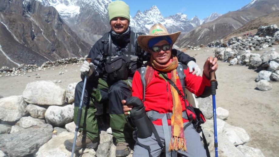
Day 02: After breakfast we set out for an extensive guided sightseeing tour of Kathmandu valley’s cultural, historical, religious and world heritage sites. During the course, we visit the famous Pashupatinath temple of Lord Shiva situated at the holy bank of River Bagmati where we will also observe the Hindu cremation ritual. We then proceed to the Boudhanath stupa, a major pilgrimage centre for the Buddhist faith which also is the largest of its kind in the world. We then have a short break for lunch followed by a visit to Swoyambhunath stupa also known as the Monkey Temple from where we can have a bird’s eye view of whole of Kathmandu valley. Following this we then proceed for a visit to Kathmandu Durbar Square, the oldest royal palace of Kathmandu and a UNESCO world heritage site. The whole are of Kathmandu Durbar Square is dotted with numerous fascinating Nepalese architect dating back many centuries. The site is also the home of Nepal’s living Goddess – Kumari, where we will also have the opportunity to experience firsthand this unique Nepali tradition. In the evening we will attend the welcome dinner hosted by Makalu Adventure with live Nepalese culture shows.
Day 03: Drive to Besi Sahar. Trek Khudi 800m
We take a private bus for the 5 hour drive to the end of the road, either at Besi Sahar or a bit farther depending on the road conditions, where we have a quick lunch and hit the trail. We have a couple of hours hot but pleasant walking to the small Gurung village of Khudi, where we spend our first night.
Day 04: Trek to Bahundanda 1310m
Leaving Khudi we trek typical middle hills. After crossing a suspension bridge at Bhulbhule, the trail passes a cascading waterfall and as we traverse the rice terraces the views of Manaslu are magnificent. Following a gentle incline we come to the village of Ngadi with its picturesque shops, cobbled streets and teahouses. From here we climb, steep and hot, to Bahundanda. Bahundanda literally means "hill of the Brahmins" and it is the most northerly Brahmin settlement in the Marsyangdi Valley, situated high up on a ridge. Great sunset views!
Day 05: Trek to Chamje 1430m
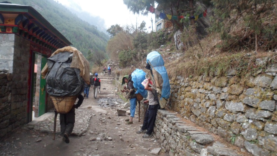
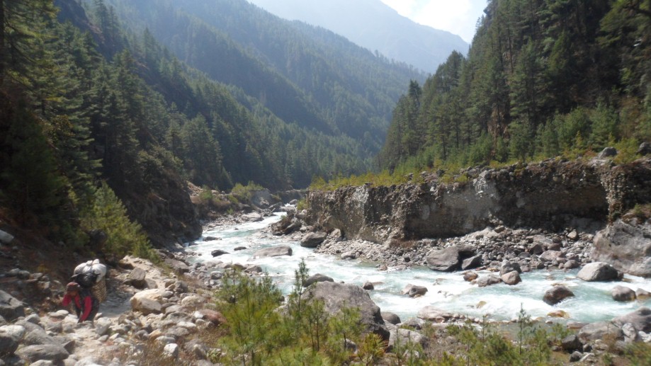
A steep trail descends from Bahundanda through green rice terraces before crossing a stream at the bottom of a small waterfall. It then climbs again and traverses the hillside high above the river before reaching the village of Hani Gaon. Ahead, the Marsyangdi valley forms a steep V-shape, and we follow the winding mountain path down through Syange and along the river for some distance. The trail then climbs steeply and the path is cut into the sheer cliff-face some 200-300m above the riverbed. Eventually we descend to the village of Jagat, situated on a shelf which juts into the precipitous Marsyangdi valley, and then climb steeply up through a forest to a wonderful teahouse just before Chamje, marked by a magnificent waterfall on the opposite bank. Chamje is an atmospheric village of traditional style teahouse, always packed with local horses, also bedding down for the night.
Day 06: Trek to Bagarchhap 1430m
Getting right into the spirit of the trek this morning, we begin before the sun hits on a two hour hike - straight up. After descending to the river and crossing a suspension bridge, we begin a steep climb to some small teahouses at Sattale. After chai, we continue on an undulating path above the river, climb the switchback path to the top of the hill, and are treated to the sight of Tal below us on a wide plain by the river. Though it is enclosed by cliffs, the level area looks reassuring after the harrowing mountain paths on which we have just traveled. Beyond Tal and the checkpost, the valley narrows and the path becomes high and winding, and in several areas is actually hewn from the rock. Beyond the small village of Karte, there is a bit more exposed trail walking before the path drops again to the river. We cross a suspension bridge, and climb the short distance to the stone kani marking the entrance to Dharapani and another checkpost. As we cut through a narrow field from the village, the Dudh Khola, which originates from the south face of Manaslu, enters on the opposite bank. The Marsyangdi then veers to the left, and as Annapurna II (the 16th highest mountain on the planet) becomes visible ahead, we arrive at Bagarchhap, a Tibetan village with prayer flags fluttering in the breeze.
Day 07: Trek to Koto Qupar 2600m
Continuing to climb through forests of pine and oak, we pass through Danagyu before coming to a thundering waterfall, where we turn left and head up the high trail to Koto. After an hour of lovely, open forests, we reach a clearing at the top of the trail and a charming Tibetan teahouse where we will stop for a break. Pausing for breath, we can look back for views of Manaslu. An hour away is the wonderful Gurung village of Timang, where the villagers might be harvesting their crops of buckwheat or stuffing local sausages. Heading back down to the village of Koto Qupar, our base for the trek up to Nar Phu, we can look straight up at nearby Annapurna II - a stunning sight convincing us that we are deep in the Himalayan mountains! Koto Qupar. The villagers are mostly from Nar and Phu and this is the gateway to their region.
* This is where the 'Remote Nar Phu' and the 'Lost Worlds of Manaslu & Nar Phu' treks meet.
Day 08: Trek to Dharamsala 3230m
This morning we head out early, as we have a long and somewhat difficult day before us. Just past the checkpost, we cross the river leading to the Nar Phu valleys, and hike up through beautiful woods above the Phu Khola (river). The route takes us through some beautiful woods and past several small shelters (caves) and a pilgrims' 'dharmasala'. As we emerge out of a narrow canyon, the trail actually passes under a wide waterfall just before the dharmasala, from which point the woods become thinner and the vistas wider. A stunning start for the Nar Phu trek! We camp at the dharamsala, a lovely campsite.
Day 09: Trek to Kayang 3740m
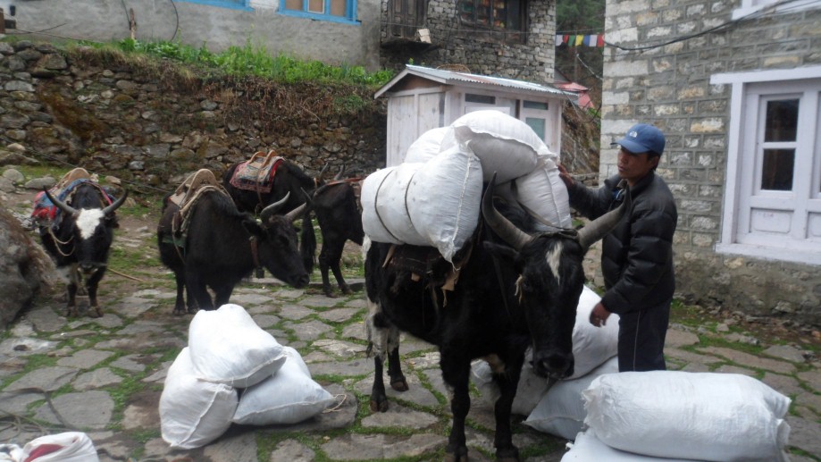
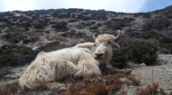
A steep climb up the valley along a small, scenic river brings us finally to high pastures on a 3,200m plateau. We pass by the scenic kharka of Meta, 3560m, a non-permanent winter settlement of Nar, where we will probably share the trail with a few yaks! This morning is one of the loveliest walks in the Himalayas. The landscape is similar to the Sierra Nevada; white rocks, low shrub and juniper, scattered evergreens, delicate brick-red and orange leafed bushes, crumbling shelves of flat slate, white, sandy trails and knarled trees. The mountains around us are utterly spectacular, and the Phu Kosi shadows the trail far below. An hour past Meta, Junam is the second semi-permanent settlement, one where "khampas" from Tibet sometimes sheltered. Above the kharka to the right looms a massive glacier, which falls jaggedly down to the high pastures above us. It's all truly amazing scenery. Across the river, the cliffs contort in swirls and waves, similar to Ladakhi landscapes. The next semi-permanent settlement is Chako, formerly a Khampa settlement, where grass lies tied in bunches to dry on all the rooftops and prayer flags flutter in the breeze. Last year we saw a massive yak caravan from Phu pass by at Chako on their way down to Manang to re-supply. A scene from old Tibet! Many more ups and downs take us to tonight's campsite at Kyang, the extensive winter settlement of Phu, on a plateau high above the river.
Day 10: Trek to Phu 4050m
Dropping steeply down to the river, we trek for a while along the river bank and past the "submarine" rock, passing some small possible campsites along the way. Today, we really start to see some of the unique, colorful chortens for which Nar and Phu are justly famous. We have to rock-hop carefully across a small glacial stream before reaching a larger one with a bridge only half covered with large slabs of slate. Some large steps do the trick! Another hour and a half of trekking through scenic canyonlands and gorges, and the "leaning tower of Pisa" monolith guards the steep trail up to the Phu gate, called Pupigyal Kwe. This ancient gate provides us with our first view of the three villages of Phu, as well as an old "dzong" and the remains of two forts, all now in ruins, but impressively situated atop the flatlands before Phu. Just before the bridge to Phu, a line of wonderful chortens color the landscape and lead the way to the main village of Phu, perched high up on a hill, amphitheater style. We will set up camp on the lower reaches of Phu, formerly called Gomdzong, and head up to the famous Tashi Lhakhang Gompa on a neighboring hillside to pay our respects to Lama Karma Sonam Rimpoche, a "trulku" who came to Nepal with HH the Dalai Lama back in '59. He is also a renowned "amchi" or Tibetan doctor, as well as a thanka painter and father of several children (some "trukus" as well as certain lamas are permitted to marry). Later, we might head up to the village to hunt down some chang.
Day 11: Phu
Having spent quite a few days getting to Phu, we will spend an extra day in the area to enjoy it, meet the local Phu residents and do some exploring up the wide valley systems above us. Tibet is two long days away, so a bit far for a visit, but we might walk up the valley to the summer grazing settlement, or "kharka" at Ngoru, a three hour's walk past the gompa. Phu itself is an incredibly interesting village, and a day is well spent sitting with the villagers as they spin their yak and sheep wool and chat, pound mustard seeds into a paste for oil, or involve themselves in the countless activities that take up a day in Tibetan villages. For photographers, the light is spectacular, and the skies a deep blue, and we may even see some blue sheep on the surrounding hillsides.
An alternative daytrip for those with lots of energy: a hike towards the east through a glacial valley leads to Himlung Himal base camp, a 7125m peak recently opened for climbing. There are usually a few expeditions climbing this peak, as well as nearby Gyanji Kang. The mountain views are tremendous! For others, a walk west up past Phu towards the chortens on the hillside provides some incredible vistas and views down over Phu and the surrounding fields, forts, valleys and peaks. A wander through the village will probably involve an invitation into someone's home for some authentic Tibetan salt butter tea, or perhaps a small glass of local 'raksi'.
Day 12: Trek to Junam 3550m
Back through Phu gate, we descend to the river, and retrace our steps back to Junam karka, a lovely spot as any for our campsite for the evening. In 2003 we camped with some Phu residents (all but one women) on their way back up to Phu with huge loads of planks from the nearby forests, and the evening was filled with Tibetan, or Manangi songs, smoky shelters and that unique Tibetan laughter.
Day 13: Trek to Nar 4150m
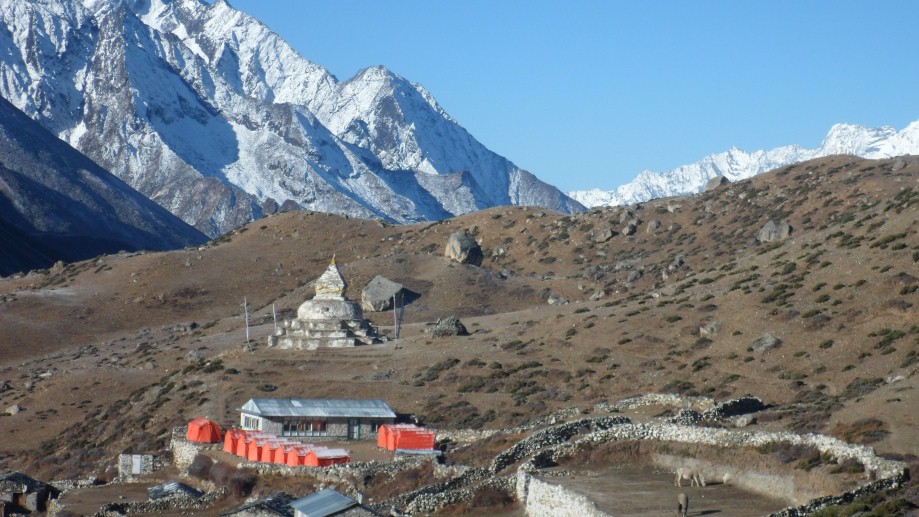
Another classic Himalayan trekking day, as we trek down to the old bridge spanning a deep, contoured and narrow gorge (cameras out for this crossing!), and then all the way back up again. It's a good thing the scenery is so stunning ... Below us sit Gyalbu Kumbu, built in 1650, and Satte gompa, both empty. We finally reach the Nar gates at the top of the hill, and pass by yet another line of wonderfully painted, bamboo-topped chortens and a large tiered chorten before turning the corner and being rewarded with sublime views of Nar, the undulating patterns of the surrounding barley and mustard fields, four old, colorful and traditional gompas and the snow-peaks looming overhead. We arrive early, so will have lunch in the sun before doing some exploring. And what exploring there is to do...
Day 14: Nar
Physically, Nar is not far from the main Annapurna trail, but it feels centuries away, is rarely visited by trekkers and is about as picturesque as they come. Nar is bit more social and lively than Phu, and the village 'square' is full of chatting women with their back-strap looms weaving wool fabric for rugs and blankets, pounding mustard seeds for oil, or spinning the ubiquitous wool while catching up on the news. The children in Nar seem to be always out in the streets, presumably preferring this life to the classroom! Each family in Nar seems to have at least one son or daughter in a gompa, and many live at home or visit frequently, so there is the resonating sound of cymbals, chanting and drums echoing throughout the village. Other Nar villagers may be printing prayer flags, doing some carpentry, collecting wood from the forest and carrying large loads with a head-strap back up to the house, harvesting the crops, tending the yaks, sheep and goats or spinning the prayer wheels in the center of town.
Alternatives for the day: visit some of the gompas, climb the prayer-flag festooned hill above Nar for wonderful views, or sit at our lovely guest house overlooking the whole scene in the sun, sheltered from the chilling and ever-present afternoon winds. It is a good day to try some local buckwheat pancakes or 'diro'. Depending on the condition of the group, we will either spend the night at Nar, or leave early afternoon for a two hour easy walk up the valley towards the pass, and camp just below the access trail to the pass by the river.
Day 15: Trek to Ngawal 3675m
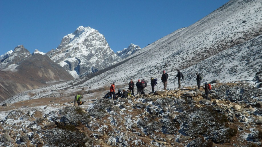
The Kang La is not a difficult pass in good conditions, but it can be a long and difficult day if there is snow on the pass or the altitude is taking its toll. The Kang La, at 5240m, is an absolutely spectacular pass looking over Annapurna II, Gangapurna, Tilicho peak, the peaks surrounding Tilicho and the airport at Thongde. The trail down initially is steep; scree jumping seems to be the easiest option for the descent. After resting sore knees and shaky legs, we lunch on a plateau overlooking the peaks, and then continue to contour to the left towards Ngawal. Ngawal, on the upper Pisang route of the Annapurna circuit (off the main Annapurna circuit), can be reached in as little as two hours from the pass, but the walk down is so nice that we will take it easy and enjoy the views. Just before Ngawal is an unusual grouping of chortens and prayer flags, and marks a meditation cave far up in the hills.
Ngawal is a wonderful, old village of cobbled streets, prayer wheels and beautiful architecture, obviously a hub of religious activity in previous times. We're finished the camping section of the trek here, and head for a guest house for the night! Hydrate before grabbing a bottle of beer, please!
Day 16: Trek to Manang 3510m
We start the day with a two hour walk through open forest to Braga, an old Tibetan-style village of about 150 partially deserted houses. We have time to explore the old village of Braga, with its large, old gompa perched colorfully above the stacked houses. The gompa has an elaborate collection of thankas and statues, and it is worth finding the key-keeper to open the assembly hall and ‘lha khangs’ for us. Braga also has an impressive collection of traditional architectural details, so keep your eyes open for beautifully carved wooden windows and doors. The prayer wheels and chorten at the foot of Braga are particularly brightly painted.
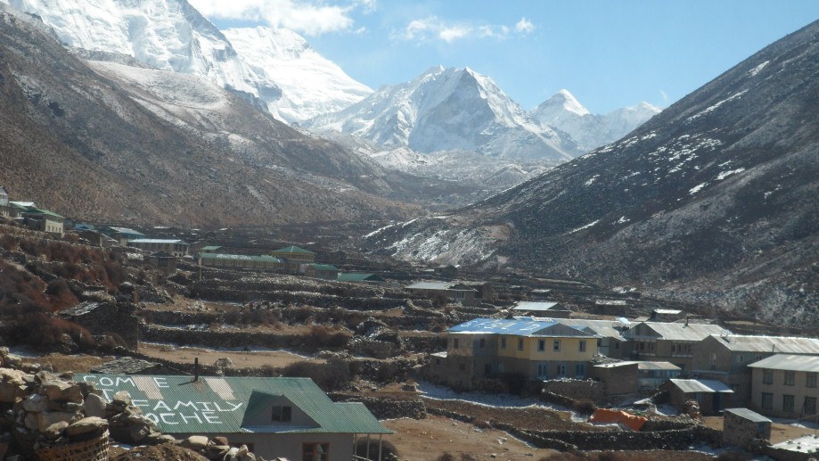
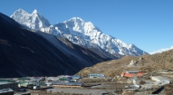
After lunch at the it’s just a 20-minute walk past a series of unique and colorful chortens to Manang, at 3500m, a village of 500 or so flat-roofed houses, the headquarters for the region, and a very interesting village packed with trekkers, bakeries and lodges. Manang is dominated by high peaks - Annapurna III and Gangapurna tower over it, and a dramatic icefall sits just across the river. There is an old gompa on the edge of town, many local teahouses, and some atmospheric, winding streets in the village leading out toward the Thorung La. There is a 3 o'clock lecture on altitude by the Himalayan Rescue Association for anyone interested. We stay at Tashi's lodge for the evening, a sort of Manangi art gallery, which also houses many of his photos of the region.
Day 17: Trek to Thorung Phedi 4525m
We will undoubtedly be passed along the trail by galloping Manangi horses, saddled with wonderful (and expensive) Tibetan wool saddle blankets, and their jubilant Manangi riders, bells jingling as they gallop by. We climb past Tengi and Gunsang to Yak Karka, and then another 45 minutes arrive in Letdar where we will have lunch. An easy two hour walk up to the Thorung La Base Camp Hotel at Thorung Phedi, and a free afternoon to either hike up to the lodge at High Camp for some acclimatization, or an afternoon of reading and chatting with other trekkers in the sunny, all-glass dining area of the lodge.
Nepal has opened a number of new peaks in Manang and new destinations like Nar and Phu, the northernmost outposts of the district bordering Tibet are added attractions. A new trekking destination is Nar-Phu, a hitherto restricted region in the remote Upper Manang valley that is home to just 850 inhabitants. Only a certain number of tourists are allowed at a given time. The region boasts of original Tibetan culture and you need to obtain a special permit to travel there. The more challenging treks are to Kang La Pass, 5,322 metres above sea level and Thorong-La, 5,416 metres. The Nar-Phu Valleys are located above the tree line on the upper limits of cultivation, in the very north of Manang district. It takes about five hours to reach the Kang-La Pass (5100 m) that links Nar with Manang and three other Bhotia villages in the Nyeshang Valley lower down. Nar has a population of some 300 villagers who depend on livestock for their living.
Day 18: Trek to Muktinath 3670m
Up early for the four hour walk to the top of the Thorung La at 5400m, where we are treated with spectacular views over Mustang and the surrounding peaks. The descent is almost as demanding as the ascent to the top of the pass, so a cup of chai and a snack at the local tea house at Chabarbu, at the bottom of the descent, is a required stop. And on to lower Mustang, which we have actually reached just after the pass, and the serene temple complex of Muktinath. We stay just five minutes down the trail from Muktinath at Ranipauwa.
Muktinath is an important pilgrimage site for Buddhists and Hindus situated in a tranquil grove of trees, and contains a wall of 108 waterspouts in the shape of cows heads spouting sacred water, the Jwala Mai temple with a perpetual spouting flame and the pagoda-styled Vishnu Mandir, all of which make up the auspicious combination of earth, fire and water.
Day 19: Trek to Kagbeni 2850m
This morning we trek along a wonderful trail through more Mustangi villages, where we will feast on delicious apples and see the traditional back-loom weaving techniques being practiced by the local women. Half an hour down the trail, Jharkot is an old Mustangi village with a medieval feel to it, a Shakya gompa which is a traditional medicine center and incredibly photogenic whitewashed houses and streets. Further along the trail at Khingar, we might visit the local school. The scenery is truly wonderful - soft light, patchworks of fields, peaks overhead, villagers out plowing the fields, horses tethered next to the houses, apple trees providing texture to the landscape. After a steep descent, we reach the windy Kali Gandaki (called the Thak Khola by the locals) river valley where it intersects the Jhong Khola, and the last village in lower Mustang, the atmospheric oasis of Kagbeni. The mud-packed houses, prayer wheels, narrow, stone streets, covered alleyways, chortens and old brick-hued gompa dominating the village and guarding the river intersections are reminiscent of old Mustang.
Day 20: Trek to Jomsom 2710m
We might take an alternative route to Jomsom down the west side of the river depending on the conditions of the trail, and the attentiveness of the check post guards (this is also officially in upper Mustang, but not strictly enforced). There are groups of villages near the trail to visit; otherwise we will walk down the Kali Gandaki riverbed, looking for saligrams along the way, to Jomsom, the administrative center for the region. Some options for the afternoon are an easy half hour walk to the beautiful village of Syang or an hour's walk across the river to the gompa at Thini. We stay at the southern end of the village close to the airport in a traditional-styled guest house, the Trekkers Inn, after checking in at the check post.
* There is an option to leave the group here and continue trekking around the Annapurna circuit.
Day 21: Fly to Pokhara and Kathmandu
If the weather is clear, we will catch a morning flight to Pokhara, and then continue on to Kathmandu the next day. The mountain views are tremendous en route. We have scheduled an extra day in Kathmandu, however, just in case we are delayed for a day in Jomsom.
Day 22: After breakfast we will set out for a sightseeing tour of Bhaktapur and Patan and return to our hotel at late afternoon.
Day 23: Transfer from hotel to airport, fly home

- All airport/hotel transfers
- All accommodation in Kathmandu and Pokhara and wherever stated
- Welcome and farewell dinner
- All accommodation and meals during the trek
- Domestic flights (wherever stated on the itinerary)
- Trek leader, assistant trek leader) Sherpa porters including their salary, insurance, equipment, flight, food and lodging
- Down jacket, sleeping bags, Trekking kit bag/duffel bag, trekking map and trekking Poles
- All necessary paper work and permits (National park permit or entrance fees etc)
- A comprehensive medical kit
- All government and local taxes
- Nepal visa fee
- Airport departure tax
- International airfare to and from Kathmandu
- Excess baggage charges
- Lunch and evening meals in Kathmandu and in Pokhara
- Extra night accommodation
- Travel and rescue insurance
- Personal expenses (phone calls, laundry, bar bills, battery recharge, extra porters, bottle or boiled water, showers etc)
- Tips for guides and porters