- Home |
- Why With Us |
- About Us |
- Booking |
- Contact Us |
- Site Map


Manaslu High Circuit
24 days (ktm-ktm) Days from
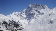
This is probably one of the best of Nepal and Tibet- a trek of amazing ethnic and scenic diversity, still relatively un-trekked; the lush rice paddies and traditional villages of Nepal\'s \'Middle Hills\' lead to high Himalayan passes, purely Tibetan villages, spectacular snow-peak panoramas and wonderful campsites.
| Max. Elevation : 4930m | Grade : Strenuous |
| Best season : Sep-Dec&Apr-June | Type of trek : Camping Trek |
| Duration : 24 Days | Starting point : Kathmandu |
| Ending point : Kathmandu | Highlights : Nature |
Our journey begins in Nepal's middle hills at historic Gorkha, with its wonderful 'durbar' (palace), home to Nepal's first kings. From these lush rice paddies with water buffalo and thatched huts, we trek north along the incredible, mountain-capped high route, through sprawling Gurung villages perched on high, terraced hilltops, to reach Kutang, or lower Manaslu. Here the ethnically Tibetan inhabitants speak their own dialect, partly Tibetan and partly Gurung, and live a lifestyle that spans Nepal and Tibet.
We continue trekking to upper Nubri, purely Tibetan, where trade with Tibet continues as it has for centuries, and we share the trails with yak caravans. The incredible mountain panoramas, dominated by Manaslu itself, begin after the first few days, and we have plenty of time to enjoy the view and meet the villagers as we have added extra days at the most beautiful Tibetan villages, Sama Gaon and Samdo, with time to visit Manaslu Base Camp and trek high up the valleys toward Tibet, before crossing the epic Larkya La pass.
Highlights
• The high Manaslu route from Gorkha
• Laprak & Barpak Gurung villages
• The Larkya La pass (5400m)
• The Tibetan region of Nubri
• The mixed Tibetan & Gurung inhabitants of Kutang
• Incredibly diverse scenery and cultures
• Spectacular mountain views and great side-trips
• Tibetan Buddhist gompas

- Day 01: Arrive Kathmandu (1340m)
- Day 02: Kathmandu
- Day 03: Drive Gorkha, trek Gorkha Camp (1060m):
- Day 04: Trek Arkole (570m)
- Day 05: Trek Kalibote (800m)
- Day 06: Trek Barpak (1915m)
- Day 07: Trek Laprak (2200m)
- Day 08: Trek Korlebesi (875m)
- Day 09: Trek Jagat (1370m)
- Day 10: Trek Philim (1570m)
- Day 11: Trek Deng (1865m)
- Day 12: Trek Ghap (2165m)
- Day 13: Trek Lho (3180m)
- Day 14: Trek Sama Gaon (3525m)
- Day 15: Sama Gaon
- Day 16: Trek Samdo (3850m)
- Day 17: Samdo
- Day 18: Trek Dharamsala High Camp (4460m)
- Day 19: Trek Bimtang (3590m)
- Day 20: Trek Tilje (2300m)
- Day 21: Trek Ta l(1680m)
- Day 22: Trek Syange. Drive Besi Sahar
- Day 23: Drive Kathmandu
- Day 24: Kathmandu
- Day 25: Depart
Detailed Itinerary
Day 01: Arrive Kathmandu International Airport, (1300m/4264ft) and transfer to hotel.
Day 02: After breakfast we set out for an extensive guided sightseeing tour of Kathmandu valley’s cultural, historical, religious and world heritage sites. During the course, we visit the famous Pashupatinath temple of Lord Shiva situated at the holy bank of River Bagmati where we will also observe the Hindu cremation ritual. We then proceed to the Boudhanath stupa, a major pilgrimage centre for the Buddhist faith which also is the largest of its kind in the world. We then have a short break for lunch followed by a visit to Swoyambhunath stupa also known as the Monkey Temple from where we can have a bird’s eye view of whole of Kathmandu valley. Following this we then proceed for a visit to Kathmandu Durbar Square, the oldest royal palace of Kathmandu and a UNESCO world heritage site. The whole are of Kathmandu Durbar Square is dotted with numerous fascinating Nepalese architect dating back many centuries. The site is also the home of Nepal’s living Goddess – Kumari, where we will also have the opportunity to experience firsthand this unique Nepali tradition. In the evening we will attend the welcome dinner hosted by Makalu Adventure with live Nepalese culture shows.
Day 03: Drive to Gorkha - trek Gorkha Fort Camp (1060m): After breakfast in Kathmandu, about 5 hour drive takes us to the historic town of Gorkha, the old capital or kingdom of Nepal, with its old 'durbar', or King's palace –the Gorkha Durbar at the top of the hill of Hindu deities, perched high up in the surrounding hillsides and reached by worn stone steps. After organizing the gear and loads with the porters, we head up many stone steps (about an hour to the fort) to our first night's campsite above the Gorkha Fort, stopping en route to visit this well-maintained site, home of the powerful Gorkha royalty until about a century ago. We can see the crew setting up camp from the top of the fort and it will only take us 15 minutes to reach camp, so linger at this atmospheric spot as long as you'd like. Notice the local 'saddhus' who stay at or visit the Hindu temples inside the fort.
Day 04: Trek to Arkhol (570m):
We wake to misty mountain views in the morning: the Manaslu range and the Ganesh Himal range are the dominant ones. Have a look over fresh coffee and chai! The middle hills of Nepal are timeless, and we trek for the first two days through classic middle hills scenery; rolling, forested hills, snaking rivers with rounded rock strewn on the beaches, local fishermen casting their nets, iridescent rice fields, papaya, lemon and orange trees, water buffalos, thatched huts and local 'bhattis' (Nepali tea-houses) along the trail for a quick dal bhat or cup of chai. More…
We have a hot seven-eight hour day for our first real day of trekking; with many locals selling bananas and papayas en route (bring small change). We'll meet many colorful Gurung and Hindu local en route, and will have time to stop at the many traditional villages along the way. We start by descending gradually on stone slab steps to scattered tea-houses, vivid green rice paddies and several small, densely populated village with a school right on the trail, the kids in the schools reciting their lessons. The next descent is very steep and slippery, a long drop down to a small bridge which leads us past more flooded rice-paddies to a dirt road which we walk along for half an hour before reaching a small cluster of tea-houses where we'll stop for a cup of tea. A quarter of an hour later, in the heat of the day, we reach a local bhatti, continue on past more terraced fields and through a small village and then climb up to a point overlooking a magnificent S bend in the Daraundi Khola far below. We descend back to the river and stop at a much needed swimming hole and rocky beach where we cool down and have our packed lunch. About 10 minutes past this stop is a long bridge where we can watch locals swimming and catching fish below us, and then past the village on the other side where cold cokes are available we cross a rickety, swaying, wooden bridge, perhaps the longest in the region. Ekle Sangu is the dingy village on this side of the river; there is a vegetable market just above the village where we will pick up a few supplies for dinner. Another hour and a half of dirt-road trekking on the left bank of the river and again through several small hamlets and bhattis brings us to a small, metal bridge over a small, intersecting bridge. We cross, hike another half an hour and reach our lovely campsite along the beach on the Daraundi River just below the small village of Arkhol.
Jump in the river and then enjoy our first mountain sunset. The village kids with surely be by to see what's happening, perhaps carry a basket of beer. Take advantage of a chance for a sun-downer while we're still low in altitude!
Day 05: Trek to Kalibote (800m):
A continuation of yesterday's lovely scenery and another six hour day, we trek though bustling Gurung villages, over several swaying suspension bridges spanning the river, past a high waterfall which tumbles to the trail, and back up just a bit to reach our camp at Kalibote in the early afternoon. Tomorrow we have a steep climb ahead of us, and this is the last campsite before the (large) hill. Head down to the river and perch yourselves on the smooth river rocks next to the wonderful swimming hole for a wash after our hot day if you like, and afterwards chilled beers are available from an enterprising little tea-house next to camp.
Day 06: Trek to Barpak (1915m):
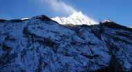
After a big breakfast; we head off early to avoid the afternoon sun for our steep, long climb up to the wonderful village of Barpak, situated perfectly on a green ridge overlooking the misty valley below. It should take us under four hours to get to camp, with several chautaras (rest stops) and the lower village and lively school en route. Barpak is a large, Ghale (royalty) Gurung village, extremely clean, with a weekly market, wide alleys between the houses, grain and vegetables drying outside on the patios, several shops, viewpoints and flowers planted along the decks of these Gurung houses. Many of its men joined the Ghurkha Army, returned to Barpak with new wealth, and have built lovely houses. We arrive in time for lunch, and have the afternoon to wander the narrow streets of the village, a photographer’s paradise. The villagers often organize 'cultural shows', the proceeds of which go to improving the village, so we might be treated to one in the early evening. At Barpak, we are towered over by Bauddhi Himal, a high, snow-capped peak which makes for wonderful sunrise and sunset photos.
Day 07: Trek to Laprak (2200m):
Another early start and a picturesque climb, with Bauddhi Himal providing a spectacular back-drop to the sprawling, scenic Barpak as we ascend the narrow ridge; we take the small, stone trail to the right of the main trail after an hour or so, and a total of three hours later, we reach the ridge, officially a pass, which separates Laprak and Barpak, and are rewarded with panoramic mountain views (along with herds of sheep grazing on the grassy hillsides) from the peak. Bauddhi Himal, Shringi Himal, Ganesh Himal and the Langtang range all span the horizon; a truly breath-taking view! If the trek is done during the spring season, the rhododendrons bloom brilliantly, in many hues of pink and red, around us, providing great photographs with the snow-peaks in back! Bring a wind jacket as the clouds often move quickly up to this ridge, and it gets cold quickly.
Another steep hour or two of trekking brings us down to another large Gurung village, Laprak, perhaps not quite as scenic as Barpak but just as interesting. Here we camp in the only campsite around, at the school in the upper section of the village, with several tea-houses nearby. Again, we have the afternoon free to explore the village; take a walk down the hill and a look into some of the houses, all with symbolic murals on the mud-brick walls. The villagers are friendly, and there is lots to explore in Laprak's winding maze of lanes.
Day 08: Trek to Korlebesi (875m):
A classic Nepali trekking day of seven to eight hours, all beautiful. We descend through Laprak's maze of village paths, the villagers on their decks with their wheat, barley and buckwheat laid out on straw mats, and descend steeply to their corn, wheat and barley fields below the village, and then to the river. After crossing a very rickety suspension bridge, we climb equally steeply back up, past terraced fields of pink sorghum and rice. We contour around several hillsides on a narrow trail, barely visible at times, up to a small chorten just below the village of Singla. From here, the going is easy, and we enjoy the views of the Manaslu Himal, Kutang Himal and Shringi Himal to the north as we walk down through more terraced fields and papaya trees, through the Gurung village of Korla, and then down along a narrow, winding trail to Korlebesi on the Buri Gandaki river. Take care as the rocky steps just before the long suspension bridge to Korlebesi are treacherous! Look out for the local women weaving straw mats in the village. Our campsite is just below the village, next to a small tributary stream, again providing great swimming holes.
Day 09: Trek to Jagat (1370m):
A five hour day today, starting with an hour of walking along the river, by tobacco and buckwheat fields, past rocks washed smooth by the river, often climbing up stone steps, to reach the hot springs in the centre of the small, terraced village of Tatopani. We have plenty of time to soak our grungy bodies in the gushing hot water, and then perhaps go for a swim in the icy river below, drying off on the wonderful river-side beach. A gentle climb through the woods past some spectacular waterfalls, across an old, wooden suspension bridge and through a short section of forest path and we reach Dobhan. Above Dobhan, the Buri Gandaki descends in an impressive series of steep rapids. Here, our trail climbs high above the river to descend through what appears to be a huge gateway into some secret place; in front the valley widens, the river calms, and we cross the river on a long, new suspension bridge and climb high on stone steps before coming into our camp below Jagat, the entrance to the Manaslu park. It is worth wandering around this beautiful, paved village, where proud villagers have recorded how much they contributed to these paving schemes. Our campsite is impressively clean and grassy, with cold beers available at the shop next door.
Day 10: Trek to Philim (1570m):
A short day, enjoy it! After descending a long series of stone steps back down to the river from Jagat, we climb on wonderful stone steps along a terraced hill-side to the small hamlet of Saguleri, from where we can see the impressive Shringi Himal, 7187 meters high. We pass through the charming, paved village of Sirdibas, where the local children sell oranges in the Autumn. Crossing the river again on a long, high suspension bridge at Gata Khola, the path splits, with the right-hand branch heading off towards the Ganesh Himal. Our route continues upstream, and again we have a steep climb to reach Philim and its Japanese sponsored school. We arrive at our grassy campsite in time for lunch, and have the afternoon free to wash at the darapani (tap) across the path from camp, explore the interesting upper village and gompa, or sit and enjoy the afternoon at camp.
Day 11: Deng (1865m):
Leaving Jagat along the main, paved trail out of Philim, we soon pass Eklai Bhatti (which means one tea-house), and trek on a high, beautiful trail through a narrow, dramatic gorge section with towering walls, past a thundering waterfall just above us on the right of the trail. We cross the river first at a narrow section of the gorge on a new suspension bridge, ascend gradually along a wide hillside through an open forest, and then cross the river two more times in the next two hours on small, very badly maintained bridges, Nepali style. The first bridge sits at the intersection to Tsum valley, a remote valley leading to Tibet. After trekking through dense woods for over an hour, we pass the cold campsite of Pewa on the river, and after another hour we leave the gorge and climb briefly to the small village of Deng. Deng is the start of the lower Nubri region called Kutang, where the people are ethnically Tibetan but speak a different dialect than the people of upper Nubri where the people are pure Tibetans. The Kutang dialect, called 'kukay', is a mix of Tibeto-Burman and Gurung. We have views of Lumbo Himal to the rear, as well as Lapuchen and Dwijen Himals. We camp just below the village.
Day 12: Trek to Ghap (2165m):
Another five hour day, similar in length to yesterday's. The valley is still steep-sided and impressive as we leave camp in the morning, heading for another bridge across the river. We switchback steeply up to the small, poor village of Lana, where the women usually have their looms out. Soon after, after more climbing through lovely woods of pine and crossing a small bridge, we reach Bihi Phedi, where there is a good shop and views of Kutang Himal, and start to see mani stones (prayers etched onto wayside rocks, particularly mani stones with pictures of gods and goddesses), a sure sign that we are entering another of the tiny Tibetan footholds that mark the high Himalayan places. We have three or four hours of trekking ahead of us, twice crossing the large Buri Gandaki and twice over smaller tributary streams, staying mostly high with many ascents and descents as we walk through the gorge, all the time enjoying spectacular views. Eventually we reach Ghap, where we set up camp for the night at the house of some wonderful villagers. The egg-shells strung above their 'tea-house' door prevent the evil spirits from entering the house.
The sun goes down early here, and we arrive early at camp, so those who want can cross the small bridge spanning the Buri Gandaki and trek steeply up for 45 minutes to the village of Chaak, where the son of the tea-house owner lives with his family. There is a small, deserted gompa, carved Mani stones (the style here is distinctly different that most other Tibetan Buddhist regions), and some Tibetans from Samdo who graze their yaks here. From Chaak, you can trek further to Kwak, and there is a trail up to Shringi Himal base camp. A fire recently destroyed the gompa at Kwak.
Day 13: Trek to Lho (3180m):
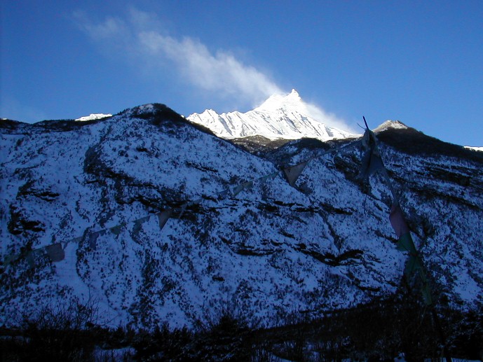
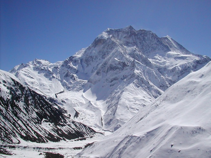
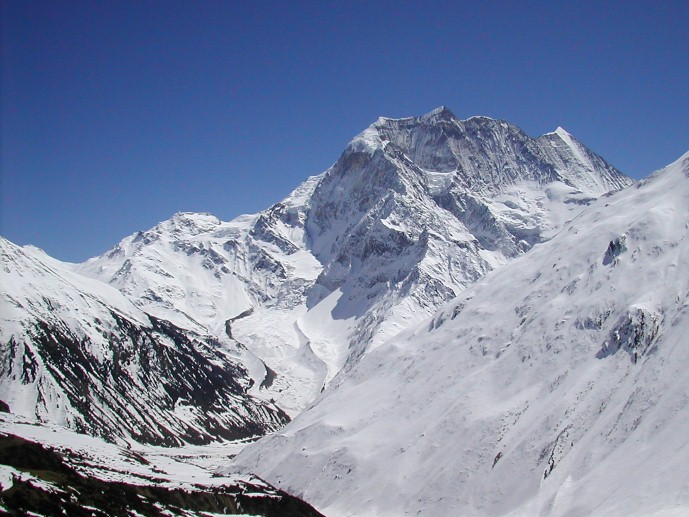
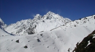
Today is a wonderful trekking day; soon after leaving Ghap, we ascend for an hour through a dense, cool forest, crossing the Buri Gandaki once on a wooden bridge, climb on smooth, stone steps and eventually arrive at Namrung, at 2540 meters, where we will stop for a cup of chai at the Tibetan-run lodge. As we gain altitude, we reach alpine territory and are treated to increasingly broad mountain views. Namrung village is the start of Nubri, the region of purely Tibetan inhabitants speaking a dialect of western Tibet. Above this village the valley opens out and there are extensive pastures. A few hours later, we reach the village of Lihi at 2840 meters, a substantial altitude gain. Lihi houses an old gompa, and is spread along the trail with its billowing fields of barley, guarded by 'bear watches'. We are climbing climb gently now; soon we cross a large stream flowing down from the Lidanda Glaciers and reach the picturesque Tibetan village of Sho at 3000m, where we stop for lunch if we haven't eaten at Lihi. Look for the bear claw on the upper deck of the house, and across the river to the ruins of an old Tibetan fort. From Sho, the views of Ngadi Chuli are spectacular, and further on, towards Lho, we are finally treated to breath-taking views of Manaslu itself; quite an impressive afternoon!
We set up camp in Lho, a lively, sprawling village adorned with many prayer flags, in the yard of a small lodge. Sunset and sunrise from the campsite are wonderful, and the small gompa just below our campsite worth a visit.
Day 14: Trek to Sama Gaon (Ro -3525m):
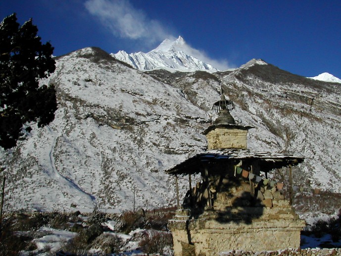
Walking through the upper reaches of Lho, with the snowy peaks of Manaslu ahead of us in the distance, we pass the new gompa and then ascend through light forests next to a small river to reach the high, idyllic Tibetan settlement of Shayla, where the villagers are often out in the fields. Amazing mountain panoramas from here! Another few hours of trekking through classic alpine scenery leads us past Tibet grazing settlements, the trail to Pung Gyan Gompa off to the left, and eventually past checkered fields of barley and potato to Sama Gaon, or Ro, as the locals call it.
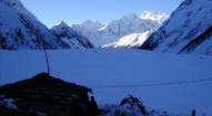
Sama Gaon sits in a bowl at the foot of the pastures leading to the high peaks, with mani walls, a small gompa and tightly packed rows of houses at the lower reaches of village, and the large gompa at the upper reaches. The people settled here from Tibet over 500 years ago, and the two gompas date from this time, both having unique architecture and built of wood. The Tibetan villages in this region of Manalsu have distinctive entrance gates (manes), and they maintain an active trade with their co-religionists in Tibet over several high passes nearby (notice the Chinese brandy and beer for sale in the small shops). If the weather is good, you will see the village women weaving wool (baal) from Tibet into gowns - which are then traded back to Tibet. Taxes were actually paid to the Dzongka Dzong (fortress) at the border of Tibet, a few days walk from Sama Gaon, as late as the 1940's until it was taken over by the Gorkhas in the late 19th century. Later, after 1959, the region was home to Tibetan guerrillas, and thus closed to trekking until 1992.
Take the afternoon to hike up to the old gompa settlement above town, and to wander the streets of the fascinating Sama Gaon village.
Day 15: Sama Gaon
We have a rest day in Sama Gaon to explore the village and gompas; a little piece of old Tibet! This is also an extra day in case anyone is having trouble acclimatizing.
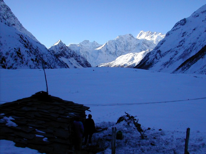
A great excursion is a hike to (or towards) Manalsu Base Camp, just north and off to the left of the trail leaving Sama Gaon, where we'll have stunning views of the lake, glacier and valley. This will take most of the day, so we'll pack a lunch for anyone wanting to go. Another option is a long day-hike up to Pung Gyen Gompa, at 3870 meters, a stunning walk up an often icy and slippery trail along the Numla Khola and the Pung Gyen glacier past Tibetan 'kharkas' or seasonal herding settlements, with unbeatable views of Manaslu near the gompa. The gompa was mostly destroyed by an avalanche in 1953, and recently rebuilt. The complex includes a cave gompa as well, which affords even better views of the valley.
Day 16: Trek to Samdo (3850m):
Another a day of incredible mountain views, past craggy woods of Himalayan Birch, during the walk up to Samdo, an easy three hours away. En route we pas the long mani walls at Kermo Kharka, after which we spot the entrance chorten of Samdo high on a bluff. We descend back to the Bhudi Gandaki and cross a small bridge before another short climb to the 'kane' entrance of Samdo.
The villagers of Samdo came across the border from the village of Riu in Tibet after 1959 and built their new village here, at their old herding settlement. Like the people of Ro, Samdo inhabitants are Tibetan, and were ceded the land by the king of Jumla over 500 years ago. Since then they have established a trade with China and India, marketing among other things, the aphrodisiac root that grows in the region. We'll see if we can get an invitation into a local house for chang (Tibetan barley beer), salt-butter tea and perhaps a bit of carpets or textile shopping. Get out and take a walk around the village, where the inhabitants live an essentially Tibetan lifestyle, herding their yaks, sheep and goats, training their horses and planting barley. There is a small home gompa in a house mid-village which we visited during our last village, a puja being held by several of the reincarnated lamas living in the Samdo.
We're high, and the wind can be chilling in the evenings, so tuck into the little tea-house next door to our campsite for a cup of salt-butter tea to warm you up!
Day 17: Samdo:
Another rest and acclimatization day in this wonderful spot below Manaslu, which towers above us. We recommend a hike up the valley directly in back of Samdo, heading towards one of their passes to Tibet, for amazing mountain panoramas. En route, we'll pass many lovely, slated herding settlements, called doksas, now empty. The prayer flags strung up on a distant hill, sending messages out into the Himalaya; make a good stopping point before returning to lively Samdo.
A longer option for the day is a trip to the Gya La ('large pass') to the north of Samdo, a more frequently used trading route to Tibet where the border markers at the top says 'China, 1962.' We will probably share the trail with groups of Samdo residents, carrying timbers over the border to Tibet. True High Asia and a long day!
Day 18: Trek to Dharamsala High Camp (Larkya Phedi) 4460m:
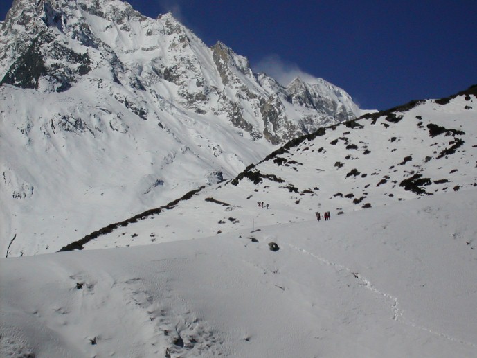
We leave Samdo on the old trade route towards Tibet, cross a bridge, and climb through the ruins of Larkya bazaar, one of the trade markets that flourished years back. After about three hours of climbing past glaciers, with increasingly awe-inspiring panoramas, we come to the campsite at Dharamsala, the high camp for the Larkya La pass, where we have lunch and gaze out at the views. You'll really feel the altitude and the cold here, so enjoy a more leisurely afternoon and keep warm. We're in blue sheep territory, so keep an eye out for herds of them grazing nearby on the barren hill-sides. We'll have an early dinner in preparation for our pass crossing tomorrow
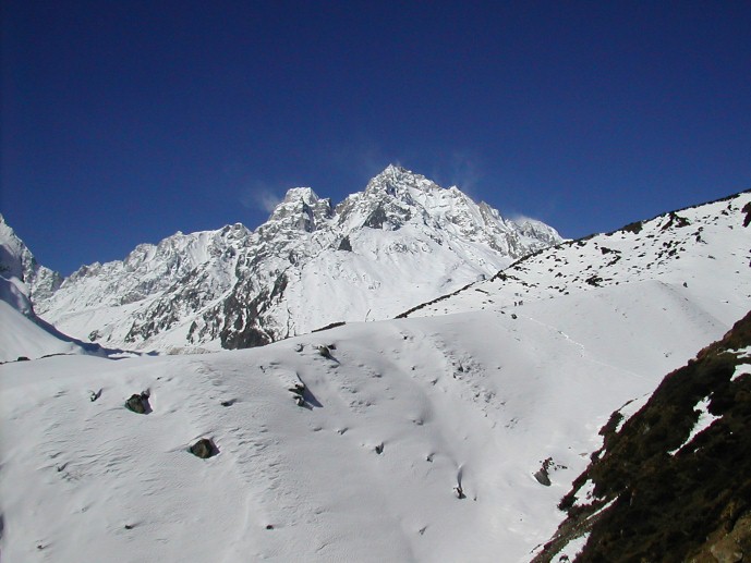
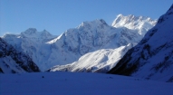
Day 19: Cross Larkya La (4930m) to Bimtang (3590m):
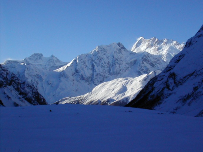
After a short climb above the campsite, we reach the ablation valley on the North side of the Larkya Glaciers where we have views of Cho Danda and then of Larkya Peak. We continue across the moraines of the glacier, often through the snow, making a gradual ascent which becomes steeper only in the last section to the pass, which should take us about four hours to crest. If there is fresh snow, we may see snow leopard prints from the evening before; it's also blue sheep, pika, marmot and Tibetan snow-cock territory.
The views from the top of the pass are wonderful; a mountain panorama of Himlung Himal, Cheo Himal, Kangguru and the huge Annapurna II, equally stunning from both sides. After hanging our Tibetan prayer flags and yelling 'Ki ki so so lha gyalo' (may the Gods be victorious), get ready for a steep, often slippery drop to a trail following the glacial moraine. Bring your trekking poles, and 'yak tracks'! We'll lunch below the pass on smooth rocks before continuing the descent, still three hours to go to our campsite. A boulder-strewn descent brings us, finally, to Bimtang where we set up the camp for tonight.
Day 20: Trek to Tilje (2300m):
A chilly but beautiful morning, as the sun hits the peaks around us long before the campsite. After leaving the grazing fields of Bimtang, we cross a boulder-strewn river, which recently flooded, on a wooden bridge and head down, down through open forests of brilliantly blooming rhododendron, past the doksas below Bimtang, passing Samdo-pa returning from shopping with their loaded horses. We'll lunch at a small tea-house, and then continue along the rocky river-bed and sliding hill-sides to several small, green villages, a sign that we've reached lower altitudes. Eventually, after a somewhat long but very scenic day, we reach the large village of Tilje, and our campsite in the lower section. The inhabitants are a mix of Manangis (of Tibetan descent) and Chettris (Hindus), so have a unique architecture and culture, and eat mix foods - dal bhat, buckwheat dhiro, tsampa and Tibetan salt-tea. The gorge ahead marks the land of apple pie, cold beers and hot showers, otherwise known as the Annapurna Circuit.
Day 21: Trek to Tal (1680m):
It's an easy trekking day following the Dudh Khola through bamboo forests down to Dharapani, an atmospheric Tibetan village with prayer flags fluttering in the wind, stopping en route at the gompa in Thongje on the old Annapurna trail. Trekking south on the main Annapurna Circuit trail, we soon arrive at a long suspension bridge over which we cross the Marsyangdi River to reach the small village of Karte, re-crossing it soon afterwards. We continue along a high, winding, stunning cliff-side trail past several small teahouses at Khorte, and then switch backing down the steep trail before crossing the Marsyangdi River yet again. Before us, we see the wide plain and waterfall at scenic Taj, the last village of the Lower Manang region. Tal means lake, and the area here was formed when the valley was blocked by a landslide and a dam formed behind. The lake has long gone and now the village of Tal sits on the river flats.
We'll set up our campsite on the grassy lawn of the last tea-house in Tal. Showers available for anyone needing one, and of course cold beers. Take the afternoon to amble over to the waterfall at the other end of town, and wander through this little hamlet.
Day 22: Trek to Syange. Drive to Besi Sahar
Continuing along the riverside, we have a quick ascent to the entrance 'kane' of Tal, and after cresting the small hump, we descend steeply past the small teahouses at Sattale, loosing even more altitude as we continue down through the lush forest to the river and cross another suspension bridge leading to Chamje -a short hike uphill. Chamje is an atmospheric, 'wild west' village of traditional-style teahouses, often packed with saddled local horses. From here the road-building is full-on, so we'll continue as far as we can get, and hop in our jeeps! But before then, one more steep descent through the woods, looking across the river to large waterfalls, leads us to the lovely cobbled village of Jagat, situated on a shelf which juts into the precipitous Marsyangdi valley. Back to the lush, semi-tropical middle hills of Nepal! Descending steeply, we arrive at the small, somewhat wild-looking village of Syange, and hope our jeep is waiting for us! We'll have a bumpy drive to Besi Sahar where we set up our last campsite and get ready for our last night's party with the staff and porters in the evening!
Day 23: Drive to Kathmandu
It's a hot, five (plus) hour drive back to Kathmandu, so we'll try to head off early and stop for lunch en route back. It is a different world back in the Nepali hills, and the gentle light sends us on our way back to the bustle of Kathmandu.
Day 24: Day at complete leisure followed by farewell dinner in the evening, hosted by the Makalu Adventure.
Day 25: Final departure.
Option:
If you wish to stay longer and undertake other adventure trips before or after the Mansslu High Circuit trip, we can offer plenty of suggestions: mountain biking in the Kathmandu valley, an Everest sightseeing flight, a trip out to Bhaktapur or Patan, the Kathmandu valley's other historic cities, or a night at the Fort Hotel in Nagarkot for a bit of luxury and some expansive sunset and sunrise mountain panoramas. Let us know if any of these are of interest to you.
- All ground transfer by private vehicles as per our itinerary
- Fine hotel –Thamel Eco Resort in Kathmandu (twin sharing including b/f and taxes)
- Welcome dinner with live Nepalese cultural program hosted by Makalu Adventure
- Guided sightseeing around Kathmandu world heritage sites including all entrance fees
- All domestic airfares (wherever applicable and stated on the itinerary)
- Organized camping trek arrangements including all high quality German Salewa / UK Super Quasar camping equipment such as two men tent, kitchen tent, dining tent, toilet tent, tables, chairs, mattresses, hot water bags, pillows, inner sheets etc.
- Everyday three times hot meals while on trekking prepared by our professional kitchen crew.
- National park, conservation area permit and fees
- Guide, porters, their daily wages, insurances with all necessary lodging / fooding arrangements.
- Administration service during rescue and evacuation (if required)
- Down jacket, sleeping bags, Trekking kit bag/duffel bag, trekking map and trekking Poles
- A comprehensive medical kit
- All government and local taxes
- Nepal visa fee.
- Airport taxes.
- International airfare to and from Kathmandu.
- Excess baggage charges.
- Lunch and evening meals in Kathmandu.
- Extra night accommodation.
- Travel and rescue insurance.
- Personal expenses (phone calls, laundry, bar bills, battery recharge, extra porters, bottle or boiled water, showers etc).
- Rescue and evacuation if required.
- Tips and gratitude